The Sea Caves of the Algarve: A Shore-Viewer’s Guide to the Coast’s Most Dramatic Geology
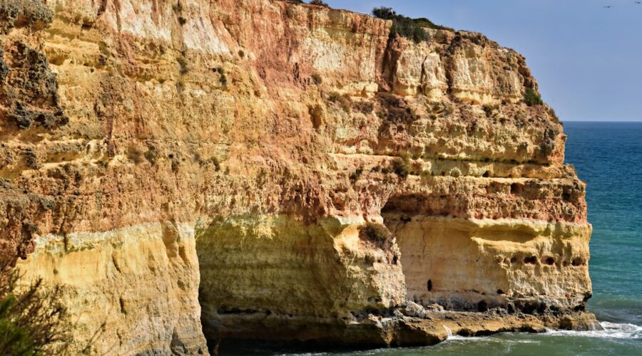
The Algarve coast is built on limestone, and where that limestone has met the Atlantic for millennia, the results are extraordinary. Sea caves, arches, blowholes, and grottoes punctuate the cliff line from Lagos to Carvoeiro — formations so dramatic that one of them, the Benagil cave, has become one of the most photographed spots in Portugal. What most visitors do not realise is how many of these features are visible without a kayak, a boat tour, or a cent spent on access. You can see them from shore, for free, and understand them better for having walked to them on foot.
The Geology Behind the Caves
The limestone that forms the Algarve coast was deposited during the Jurassic period, roughly 150–200 million years ago, when this area lay under a shallow tropical sea. That limestone — known locally as calcário margoso — is relatively soft and stratified, layered with bands of harder and softer material. When the Atlantic rose at the end of the last ice age, roughly 12,000 years ago, wave action began attacking these layered rocks at their weakest points: the softer bands eroded faster, while harder layers above formed natural roofs. The result, over geological time, is the cave-and-arch system you see today.
Three processes shape the caves simultaneously: hydraulic action (the physical force of waves and the pebbles they carry), abrasion (sand and rock fragments wearing at the walls), and chemical weathering (salt and seawater reacting with the calcium carbonate in the limestone). The Algarve’s caves show all three in different stages of development — some are still being carved, others have collapsed to form sea stacks, and a few have been uplifted above sea level by the ongoing tectonic adjustment of the Iberian peninsula.
The Grotto of Saint Anthony (Luz)
The Gruta de São António, directly below the clifftop path between Lagos and Luz, is the most accessible significant sea cave on the Algarve coast. A set of wooden steps descends from the clifftop car park to a concrete platform at cave mouth level, where you can stand and look directly into a vaulted chamber roughly 20 metres wide and 15 metres deep. At high tide the waves reach the platform. At low tide you can walk along the base of the cliff for another 50 metres and see the cave from the side, where the striated limestone layers are clearly visible — lighter and darker bands representing different periods of marine deposition.
The cave is named for a hermit monk who reportedly lived here in the 16th century, though no documentation of that occupation survives. What is documented is that the cave served as a smugglers’ refuge in the 18th and 19th centuries — its location, invisible from the sea approach and accessible only from the clifftop, made it ideal for concealing contraband goods.
How to reach it: From Lagos, take the clifftop path west toward Luz (the Trilho dos7 Faróis signposted from the lighthouse car park). After roughly 20 minutes you reach the cave access steps on your right, marked by a small metal railing. Parking is limited; arrive before 10:00 on weekends or use the Lagos town parking and walk the path.
The Benagil Cave (Praia de Benagil)
The Benagil sea cave has become the Algarve’s most famous geological feature — a cathedral-like vault open to the sky through a natural oculus, surrounded by orange-tinted limestone, accessible only by boat or at very low tide by swimming from the neighbouring beach. But the cave itself is only the most dramatic element of a longer section of cliff between Benagil and Carvoeiro that contains at least six other significant caves and arches.
From the clifftop path above Benagil beach, you can look down into the cave mouth when tide and light allow. The best vantage point is from the wooden viewing platform at the northern end of the Benagil beach car park — from here you can see the oculus clearly, and on calm days you can see the sandy floor of the cave below, normally occupied by kayakers.
The geological formation is a karstic cavity — a cave formed primarily by chemical dissolution of the limestone by groundwater, later breached and shaped by marine action as sea levels rose. The oculus is a collapse feature: the roof of an earlier, larger cave chamber fell inward, leaving the current open-top structure. Similar formations exist in the Maltese islands and in parts of Dalmatia, but the Benagil cave’s combination of accessibility, scale, and vivid colour makes it unique in European coastal geology.
How to reach it: Park at Benagil beach (paid parking, approximately €3/day in summer, free in spring). Walk north along the clifftop path. The viewing platform is a five-minute walk from the car park.
The Grotto of the Marmosets (Carvoeiro)
The Gruta dos Minhos — popularly called the Gruta dos Macacos — is a sea cave on the Carvoeiro clifftop walk that is accessible without any special equipment or boat. A gap in the cliff face opens into a vaulted chamber roughly 15 metres across, with a natural pillar of limestone at its centre. The cave takes its popular name from the way the rock formations at the entrance resemble primate faces when seen from certain angles in the low morning light.
The cave is part of the same limestone formation system as the Benagil cave, but in an earlier stage of marine development. The entrance arch is wider and lower, indicating more advanced erosion, and the internal pillars are remnants of what was once a complete ceiling. You can walk to the cave mouth from the clifftop path — it is clearly signposted on the Carvoeiro boardwalk route — and stand at the entrance looking in. At high tide the waves wash through the entrance arch.
How to reach it: The Carvoeiro clifftop boardwalk (Passeio dos Clássicos) is accessed from the Carvoeiro beach car park. Follow the wooden boardwalk north along the cliff. The cave is signed and approximately 400 metres from the beach.
The Sea Arches at Praia do Camilo
Below the famous staircase descent to Praia do Camilo, a series of smaller sea arches has been carved into the cliff face by centuries of wave action. These are best seen from the beach at low tide, when you can walk along the base of the cliff and look up into the arch chambers. The smallest arch is roughly 2 metres wide; the largest is large enough to walk through at low tide, connecting two pockets of sand on either side of a limestone promontory.
The Camilo arches are particularly significant because they show the full geological sequence in a short space: intact cliff, initial notch (wave-cut cave), arch formation, and collapsed-stack remnant. This makes the 200-metre stretch an outdoor geology lesson.
How to reach it: Follow the wooden staircase down to Praia do Camilo from the clifftop car park on the EP5502 road between Lagos and Luz. At low tide, walk right (east) along the beach base to reach the arches.
Understanding the Caves Responsibly
Marine caves are fragile environments. The biological communities inside — lichens, mosses, sheltered tide pools — are easily damaged by foot traffic and游客 pressure. The Benagil cave in particular has suffered significant erosion damage from thousands of visitors arriving by kayak and boat each summer. The oculus rim has visibly softened in the past decade.
From a responsible visiting perspective: see the caves from the clifftop where possible. If you visit by kayak or paddleboard (which are permitted at most caves outside the summer high season), do not touch the walls, do not remove any material, and do not enter the Benagil cave at all during July and August when it is effectively a tourist queue rather than a geological site.
Practical tip: Spring and early June are the best months for clifftop cave viewing — the light is lower and more horizontal, illuminating the cave interiors more dramatically, and the sea is usually calm enough for safe kayak approaches if that is your plan.