The Salt Roads of the Algarve: Following the Ancient Routes From Portimão to Castro Marim
Salt is the first thing the Algarve exported to the world, and it is the last thing most visitors think of when they come here. The coastal marshes and tidal flats that line the eastern Algarve — from the margins of the Arade estuary near Portimão through the Ria Formosa lagoon system to the Castro Marim salt pans — have been producing salt continuously for over two thousand years. The Romans shipped it north. The Phoenicians traded it across the Mediterranean. The Moors built the evaporation systems that are still recognisable today. And for most of that history, the salt travelled inland by ox-cart along routes that have now become minor roads, village lanes, and in some cases, footpaths.
Understanding the salt roads of the Algarve is one of the most direct ways to understand the region’s actual history — not the history of the beach resorts, which is a product of the 1960s, but the older history of a place that fed itself and its neighbours through the careful management of tidal water and coastal flat land. This is a route you can follow by car in a long day, or by bike over two days, with stops at working salinas, small museums, and the villages that grew rich on the salt trade and have since returned to quiet.
The Salt Road Concept
The Algarve’s salt roads are not a single documented path but a network of routes that radiated outward from the main production areas — Portimão and the Arade estuary, the lagoons around Lagoa and Carvoeiro, the Tavira channel, and the Castro Marim flats — toward the interior markets of the Alentejo and ultimately Lisbon. What survives today is fragmentary: some sections are incorporated into national roads, others have been paved over, and a few remain as unpaved lanes between farmland and salt marsh.
The most coherent surviving section runs between Castro Marim and the interior market town of Alcoutim — essentially the road now signed as the M501, which was historically the main salt export route from the eastern salt pans to the Alentejo grain farms and ultimately to the Spanish border crossings. Driving this road today, you pass through a landscape that has not changed dramatically since the 18th century: flat coastal plain, salt pans to the south, dry-farming wheat to the north, the road itself slightly elevated above the flood level, bordered by the whitewashed marker posts that still mark the route in places.
Portimão and the Arade Estuary
The salt trade of the western Algarve was centred on the Arade estuary, where the Portimão and Lagoa salt pans have operated since at least the Roman period. The salt produced here — coarser and darker than the fine white fleur de sel of Castro Marim — was traded primarily for fish. The entire Portuguese preserved fish industry, from the sardine fisheries of Setúbal to the cod trade of the north, depended on Algarve salt for preservation. The Portimão museum of regional ethnography contains a detailed section on the salt trade and its role in the development of the town, with maps of the old cart routes and photographs of the salt-working families from the early 20th century.
The remaining salt pans near Portimão are smaller than the Castro Marim operation but still active. The access is limited — the pans themselves are private working sites — but the margins of the estuary can be walked along public paths, and the salt is sold at a small number of outlets in the town.
The Lagoa and Carvoeiro Corridor
The salt pans between Lagoa and Carvoeiro are some of the most visually dramatic on the coast — the vivid pink and turquoise of the evaporation ponds against the grey-green of the coastal scrub, visible from the cliff path between Carvoeiro and Benagil on clear days. These pans were historically smaller than the Castro Marim operation, serving a local rather than an export market. The salt produced here was traded at the weekly market in Lagoa town, and the old market day route from the coast to the inland market town of Silves is still partially traceable as a secondary road.
The most interesting surviving section of this route is the road from Carvoeiro to the IC1 — a short stretch of about 4 kilometres that follows the natural contour line above the coastal plain. It is now a quiet municipal road with little traffic and excellent views across the pans to the sea beyond. Cycling it in the early morning, before the coastal road traffic builds, gives a clear sense of why this route was chosen and why the salt it carried was prized.
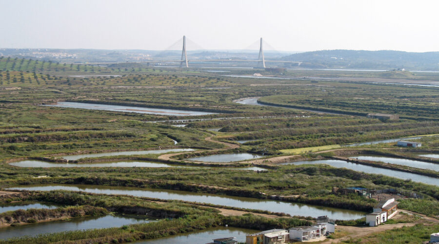
Castro Marim and the Eastern Salt Roads
The Castro Marim salt pans are the largest and most productive on the Algarve coast, and they have been continuously operated since the Moorish period. The salt produced here — particularly the fleur de sel harvested by hand from the surface of the final evaporation pond — is considered among the finest in Europe and commands prices that reflect its quality. It is sold in the on-site shop, in several markets in Tavira and Lagos, and in a small number of specialist food shops further afield.
The salt roads from Castro Marim ran north and east. The eastern route crossed the Guadiana at Alcoutim and continued into the Spanish interior, trading salt for the products of the Spanish dryland farms. The northern route went inland through the interior villages toward the Alentejo. Both routes are documented in 18th and 19th century commercial records, and both are substantially intact as minor roads.
The M501 from Castro Marim to Alcoutim is the most intact surviving section of the northern salt road. Driving it slowly — 40 to 50 kilometres per hour — you pass through a landscape that has not changed substantially in two centuries. The road is elevated above the flood plain, bordered by the original stone markers, and flanked by the dry-farming land that received the salt in exchange for grain. The villages along the route — Vaqueiros, Martim Longo, São Barnabé — grew as staging posts on this trade, and their market day economies still reflect this origin.
How to Follow the Salt Roads Today
The most practical approach is a two-day route that covers the coastal salt pan sites on the first day and the inland route on the second. Day one: visit the Castro Marim salt pans in the morning (allow two hours for the walk and the visitor centre), drive to Tavira for lunch and a walk along the Ria Formosa margins, then continue west to the Lagoa pans viewpoint and the cliff path between Carvoeiro and Benagil for the evening light. Day two: depart early from Tavira or Lagos and take the M501 from Castro Marim toward Alcoutim, stopping at the villages along the route, visiting the Alcoutim river walk and museum, and returning via the eastern interior roads.
By bike, the route from Castro Marim to Alcoutim is a day ride of approximately 60 kilometres return — flat, quiet, and one of the most interesting long-distance bike routes in southern Portugal. The road surface is mixed: good tarmac on the main sections, rougher on the approach to Alcoutim. Cycling it in autumn or early spring, when the heat is manageable and the light is at its best, gives the strongest sense of why this route existed and what it carried.
The Salt Itself
If you want to bring something home that actually represents the Algarve, a bag of Castro Marim fleur de sel — harvested by hand, sold in the salt pan shop, costing roughly €8 per kilogram — is a better souvenir than any cork product or ceramic piece sold in the coastal tourist shops. It is lighter to carry, it will not break, and it is something that you will actually use. Ask in the salt pan visitor centre for the different varieties available; the flor de sal and the.rapa are distinct in flavour and worth understanding the difference.
The salt roads of the Algarve are not a tourist attraction. They are a working cultural landscape that has been in continuous operation since before the Romans arrived, and following them is a way of seeing the region that most visitors never find.