The BTT Trails Around Aljezur: Mountain Biking the Costa Vicentina
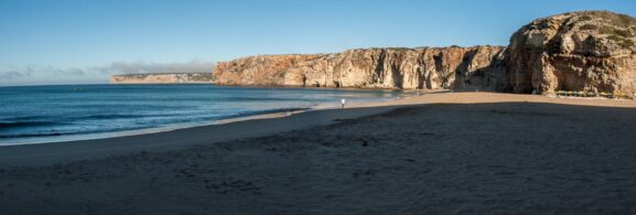
Photo: Bextrel · Wikimedia Commons · CC BY-SA 4.0
Aljezur is in Aljezur municipality, on the western Algarve coast and within the Southwest Alentejo and Vicentine Coast Natural Park. The town provides access to the Rota Vicentina walking routes and nearby BTT routes. For confident cyclists seeking uneven, off-road terrain rather than a surfaced coastal cycle path, the area offers several practical route options.
This is not a beginners’ guide. You need adequate fitness, a suitable mountain bike, and experience riding singletrack on uneven surfaces.
The BTT routes
The wider Rota Vicentina cycling route connects Santiago do Cacém in the Alentejo with Cape Saint Vincent, or Cabo de São Vicente, in the Algarve. Around Aljezur, riders can choose among longer through routes, local circuits, and links toward the coast. Check the current official route map before setting out because access and route conditions can change.
- Long-distance sections: These use a mixture of forest tracks, uneven trails, and sandy stretches. Divide the route into stages that match your fitness, daylight, and water capacity.
- Circuits around Aljezur: Local loops start and finish near the town and can be used for day rides. Distance and elevation vary, so check the route profile rather than judging difficulty from distance alone.
- Links toward the coast: Routes connect the inland network with areas near Arrifana, Bordeira, and Amoreira. Expect more exposed terrain and changing surface conditions closer to the coast.
The terrain varies substantially. Inland sections use dirt roads and forest tracks through plantation areas. Coastal sections can include exposed hills, loose sand, and rocky singletrack. Check recent trail conditions, especially after rain or strong wind.
Difficulty levels
The routes do not all follow a single difficulty grading system. Assess each section using its surface, elevation profile, exposure, and technical features.
- Less technical: Wide, firm forest tracks with limited traffic. These may suit experienced road or gravel cyclists who are comfortable on loose surfaces, provided the route does not include technical connecting sections.
- Moderate: Narrow trails, occasional rocks, and controlled descents. These require reliable braking and basic off-road handling skills.
- Difficult: Rocky or exposed singletrack, loose sand, steep gradients, and abrupt drops. These sections require mountain biking experience and are not suitable for beginners.
Using Aljezur as a trail base
Aljezur is a practical starting point because public roads and marked routes provide access to both inland and coastal terrain. Confirm the intended start point, parking rules, water availability, and current trail status before leaving town.
Inspect the bike before every ride. Brakes, tyres, suspension, chain, and wheel fastenings must be suitable for the planned terrain. Sand and salt can accelerate wear, so clean and inspect the bike after coastal sections.
Natural park rules
Parts of the route network cross the Southwest Alentejo and Vicentine Coast Natural Park. Protect sensitive dunes, cliffs, vegetation, and wildlife by following the current rules and posted signs.
- Stay on routes where cycling is permitted and do not create shortcuts through dunes or cliff vegetation.
- Do not cycle on paths designated only for walkers, including walking-only sections of the Fishermen’s Trail.
- Use authorised campsites or other permitted areas rather than camping inside protected areas without permission.
- Check for temporary closures, fire restrictions, maintenance work, and seasonal access limits before starting.
What to bring
- A mountain bike in good mechanical condition and appropriate for the route’s technical level
- A helmet, gloves, puncture repair equipment, a pump, and basic tools
- Enough water and food for the route, with extra capacity when public refill points are uncertain
- An official route map, downloaded GPX file, or offline navigation, plus a charged phone and backup power
- Sun protection, an insulating layer, and a windproof layer for exposed ground
- Emergency contact details and a route plan shared with another person
When to ride
Spring and autumn generally offer more manageable temperatures than midsummer. Heat and limited shade can make exposed sections demanding in summer. Rain can leave tracks muddy, eroded, or difficult to cross in winter. Check the weather, fire risk, daylight, and recent trail reports before choosing a route.
Relationship with the walking trails
The cycling and walking networks sometimes run near each other but do not always use the same paths. Do not assume that a marked walking trail permits bicycles. Use the current cycling map and follow signs at junctions, particularly where the route approaches the Fishermen’s Trail or sensitive coastal ground.
Summary
The BTT routes around Aljezur range from broad forest tracks to exposed, technical singletrack. Choose a route by surface, elevation, and technical difficulty. Carry water, navigation, repair equipment, and suitable clothing. Within the natural park, remain on routes where cycling is permitted and check current conditions and restrictions before setting out.