Sagres Beyond the Lighthouse: What Nobody Tells You About Portugal’s Edge
Photo: Tony Hisgett from Birmingham, UK · Wikimedia Commons · CC BY 2.0
Sagres Beyond the Lighthouse: What Nobody Tells You About Portugal’s Edge
Most visitors to Sagres do the same thing: they drive out to Cabo de São Vicente, photograph the lighthouse, and leave. Twenty minutes, maybe thirty. That is the version of Sagres that fits into a day trip from Lagos.
It is also the version that misses the fortress, walking routes and historical context.
Sagres merits a full day. Here is how to spend it.
The Fortress: Why It Matters
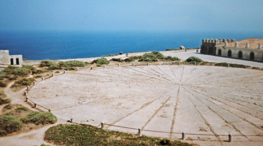
The Fortaleza de Sagres is associated with Prince Henry the Navigator and Portugal’s maritime expansion during the 15th century. Claims about a formal school of navigation at Sagres remain disputed. The site includes substantial stone walls, a large compass rose, a cistern, a chapel and views across the surrounding coast.
The ticket covers the fortress grounds and interpretive displays. Allow about 60 to 90 minutes. There is not an enormous amount of text, so a slow walk is more useful than a rushed sweep.
Practical details:
- Opening hours vary by season. Check the official schedule before making a long journey.
- Ticket prices can change. Check locally for current pricing.
- Parking is available outside the fortress entrance.
- Most of the interior is flat, but surfaces near the outer cliffs are uneven.
The Cliff Walks Around Sagres
The fortress sits at the edge of a coastal plateau cut by steep ravines. Paths cross the clifftops around the headland, with views across the Atlantic. You can choose a short walk or continue farther along the coast. Footing varies, and exposed sections can be windy.
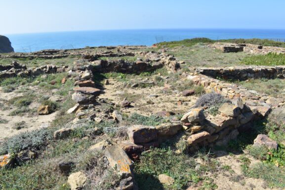
One route follows the coast from the fortress toward Cabo de São Vicente. Another leads from the fortress area toward Ponta da Atalaia, where there is an archaeological site and a viewpoint. Choose the route according to the weather, available daylight and your comfort near exposed cliffs.
What to know about the wind: This is an exposed part of the Algarve coast. Strong gusts can make cliff walking uncomfortable or unsafe. Check the forecast before setting out and keep well back from cliff edges.
The Interpretive Exhibition
The exhibition inside the fortress complex provides context on navigation, Portuguese maritime history and the role associated with Sagres. Allow about 30 minutes if the history interests you. If your priority is walking, spend more time outside on the headland.
Combining the Fortress With Cabo de São Vicente
The fortress and Cabo de São Vicente can be visited on the same day. A coastal route connects the two areas, but conditions and walking times vary. Driving is the more practical choice when the weather is poor or daylight is limited.
Cabo de São Vicente is the southwesternmost point of mainland Portugal and continental Europe. Its public clifftop areas face the open Atlantic. Rough weather can send spray toward the cliffs, so remain behind barriers and away from exposed edges.
Late afternoon gives you time to inspect the conditions before sunset. Check the local sunset time and allow enough daylight for the return journey. The area near the lighthouse becomes busier toward sunset, while the surrounding paths may be quieter.
What to Bring
Bring drinking water, food, sun protection and a wind resistant layer. Services are limited around the fortress and Cabo de São Vicente, so carry what you need for the time you plan to spend outdoors.
Full Day Itinerary
A practical way to structure your time:
- Morning: Arrive at Sagres Fortress. Walk the grounds and explore the interpretive exhibition.
- Late morning: Take a clifftop walk near the fortress, choosing the length according to the weather.
- Early afternoon: Stop for food you have brought and allow time to rest.
- Mid afternoon: Walk toward Ponta da Atalaia or explore another public path near the fortress.
- Late afternoon: Continue to Cabo de São Vicente and assess the wind, visibility and cliff conditions.
- Sunset: Watch from a safe public viewpoint, then leave while there is enough visibility to reach your vehicle or transport stop.
This provides a full day with history, walking and coastal scenery without requiring a rigid schedule.
Honest Assessment
The Sagres fortress is less ornate than the Pena Palace in Sintra and less intact than the castle in Silves. Its value lies in the historical context, exposed setting and direct relationship with the Atlantic coast.
Crowd levels vary. The lighthouse parking area can become busy before sunset. The fortress grounds and paths between the main viewpoints may be quieter, but conditions change by season and time of day.
Spring can bring cooler walking conditions, wildflowers on the coastal slopes and migrating seabirds. Wind and visibility remain the more important factors when deciding when and where to walk.
Getting There
- From Lagos: Allow around 35 to 50 minutes by car and follow the signed route toward Vila do Bispo and Sagres. Check current public transport schedules if travelling by bus.
- From Faro: Allow around 90 to 120 minutes by car, depending on traffic and the route.
- From the central Algarve coast: Allow around 60 to 90 minutes by car, depending on your starting point and traffic.
Sagres and Cabo de São Vicente sit on the western Algarve coast. Beyond the fortress and lighthouse areas, the public headlands and Atlantic views are the reason to allow more than a brief stop.