
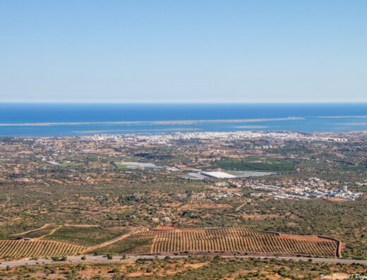
Cerro de Cabeça is where the Algarve turns inland without losing sight of the sea. The pull here is simple: a rocky climb, a marked path, and a viewing platform with a broad line back toward the coast. It is a better fit for photographers who like rough ground and open landscapes than for anyone looking for a polished roadside lookout.
The ground gives the place its character. The route is rocky and uneven, with rubbly sections underfoot, so the pictures are not only from the platform. Low stone, scrubby hillside, green meadow textures and exposed rock all sit in the frame before the view opens out. If you continue above the formal viewpoint toward the trig point, the terrain becomes much more awkward, with large boulders and gaps that are easy to underestimate.
When to go: work with clear weather if you want the coast to read cleanly in the frame. Spring has the strongest clue for foreground interest, with flowers, green fields and birdsong mentioned from the hill, but the main subject is evergreen: height, rock and the inland-to-coast view.
Access is via a signed trail after leaving the main road. The path is described as straightforward and well marked, but the surface is uneven throughout and the climb is steep enough to matter. Watch the ground at the top as broken glass has been noted there.
Who it’s for: landscape photographers, walkers with a camera, and anyone building a Moncarapacho inland circuit. It works best as a stop rather than a whole-day destination: worth the climb for the viewpoint and rough hillside texture, but not a place to over-plan.
About This Spot
-
General AreaNear Moncarapacho, Algarve
-
Coverage BadgeArchive
-
Best Seasonany
-
Difficulty3 Advanced
Getting There & Access
-
Getting ThereTurn off the main road near Moncarapacho and follow the signs to the marked trail up to the viewpoint. The route is rocky and uneven, with a steeper, more difficult continuation above the viewing platform toward the trig point.
-
Access Termsfree-public
Photography Notes
-
Shooting NotesUse the viewing platform for the open coastal view, and include rocky foreground or hillside vegetation from the marked path. Do not assume the trig point is part of the easy route; the ground above the platform becomes much more difficult.
-
ConditionsUneven rocky ground and rubbly tracks. Broken glass has been noted at the top, so careful footing matters.
Visitor photos


Location
Log in free to see the exact pin and directions.

Leave a Reply
Been here? Add your shots.
Photos you add appear on this page with your name on them, next to the community gallery. Tell the next photographer what you found: the light, the crowds, whether it was worth the trip.
A free account also unlocks the exact pin, how to get there and the best time of day, on every spot.